At least 12 ships have come to grief in the strong currents and dangerous reefs which lie off Cape Naturaliste sharp point.
| The lighthouse's predecessor was known as 'The Tub' - it was a barrel on top of a 30 foot pole in Busselton which marked the best landing place for passengers and stores. Later a lantern hung from the top of the pole so it could be seen at night. In 1873, this was replaced by a wooden structure called 'The Lighthouse'. Which was later pulled down. The Lighthouse now was constructed in 1903 from local limestone, quarried about one mile from the lighthouse at what is known as the "Quarries". Bullock wagons carted the stone from the quarry and most of the other materials and apparatus landed at nearby Eagle Bay. This included the lens and turntable weighing 12 1/2 tons. The light was exhibited for the first time in 1904. |
On arrival we noticed you could do a 2km loop walk around the lighthouse and we thought that sounds like a great idea...so off we went...but some where along the way we took the wrong path and ended up on the Cape to Cape track which runs for 135 km along the Leeuwin-Naturaliste Ridge between the lighthouses of Cape Naturaliste and Cape Leeuwin in the far south west of Western Australia. Hummmmmm.. we really didn't have time to walk that distance today lol !!!
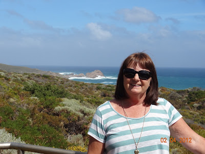
As we were walking along I kept saying to John... that the light house seems to be going far away from us not coming closer as it should in the loop... but the view we were experiencing were so nice we just plodded on... spectacular coastal and forest scenery, even little critters like this on the path....
Breathtaking panoramic views of the Indian Ocean, Cape Naturaliste, Leeuwin-Naturaliste National Park and the beautiful Geographe Bay coastline.
Once we got back to the lighthouse and checked out the maps we had walked over 7 half kms... Now we were hungry and thirsty so we headed out stopping at a place called Bunkers Bay where we had a lovely lunch and a glass of wine...
We then went to check out the beach which the cafe overlooked... the sea was so rough, yet people were in there surfing...
In the distance we spotted really big waves at the point so we decided to go for a drive around to it and check it out...


No comments:
Post a Comment